| 05-15-06
Everybody
talks about the weather, but nobody does anything about it.
--The Hartford Courant, August
24, 1897
Weather, it has been said, is something we
will have . . . whether we like it or not.
I cant tell you who said that, but I can tell
you that weather is a great factor in the success or failure of outdoors
types sashays into the wild--more specifically, those who hunt, fish,
or forage for the many forms of natural produce.
So, if you think in these terms--or even if you
dont--write down this word (if we may loosely call it a word): CoCoRaHS.
Outdoor pursuits are not requisite to wanting to know what the weather
will be. There are many uses for information on weather-related data.
CoCoRaHS is not a word, but an acronym for Community
Collaborative Rain, Hail and Snow network. But it is much more than an
acronym. It is a network of people of many walks of life (including many
weather professionals) who pool their talents and efforts to record the
results of weather fronts that the data may be used for many purposes,
including the efforts of outdoor types.
The network was launched by Colorado Climate Center
at Colorado State University in 1998, and now is operating in 12 states,
including Indiana. Although professional weather/climate workers are the
backbone of the network, run-of-the-mill folks are used/needed/sought for
participation as volunteers to maintain and read rain gauges, and to report
their findings.
To learn more about becoming a COCoRaHS volunteer,
or to check rainfall or hail amounts around Indiana, or other participating
states, open the organizations web site, www.CoCoRaHS.org.
The menu of the opening page will open the door
to all kinds of information, including the precipitation reports from various
points around Indiana or other participating states.
Goal of the network is to have an observer for
every square mile of urban areas and one observer for every 36 square miles
of rural areas.
Potential weather observers of the network should
attend a training session, but individuals can arrange a training session
by contacting Ken Scheeringa, CoCoRAHS@Purdue.edu, or Logan Johnson,
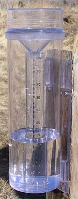
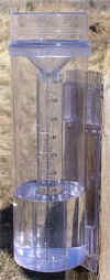
Logan.Johnson@noaa.gov. Observers will need a CoCoRaHS rain gauge (four
inch diameter). Volunteer observers who do not have such a rain gauge will
get one free from the network.
Upcoming Indiana training sessions are scheduled
for Goshen, May 18; Washington, May 23, and New Albany, May 25. More information
on these sessions, and others to be offered, is available on the network
web page. Sites for other training sessions will be announced in the future.
Those who do not care to participate in the program
can still use data others collect by simply opening the website,
clicking on the map of Indiana (or another participating state), and opening
the precipitation report.
Data on precipitation for Indiana also is available
by opening the report of the Indiana State Climate Office at Purdue University.
This address is www.iclimate.org.
When this web site opens, click on Request Information . . . then click
on automated data."
This will open a form that will instruct the visitor
to type in his e-mail address before clicking on continue. From there
the visitor needs only to request the desired information by clicking on
a map location and placing check marks in boxes.
Two other good sources of weather-related data
are the web pages of the US Army Corps of Engineers Louisville District
office (www.lrl.usace.army.mil)
for data on Indiana multi-purpose reservoirs, and the US Geological Survey
(http://waterdata.usgs.gov/in/nwis/rt)
for readings on gauges of many Hoosier streams and rivers.
When the Engineers web page opens, scroll down
to Louisville District. Then click on Rivers, Lakes, Locks and Dams
and Recreation Information. That will open a page called Operations Division.
Scroll down to and click on Lake levels.
When the Geological Survey page opens, click on
Rivers Grouped by River Basins.
Combining local rainfall data with water levels
of rivers and reservoirs from your home can avoid the frustration that
can come when along drive ends in learning that the water is not right
for fishing, hunting, or some other outdoor activity.
| This
is the official CoCoRaHS rain gauge, available to volunteers in the program. |
 |
|